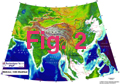
In the debate about continental deformation localisation, the example of the India-Eurasia collision zone has focussed the attention of many scientists because it is the largest active one on Earth (Figs 1, 2 and 3).
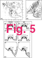
Since 1982, Tapponnier and co-workers, starting from plasticine experiments and field observations followed by detailed laboratory analyses, have promoted the idea that a large fraction of Asian deformation was taken up by successive extrusions of large coherent continental masses along great strike-slip faults (e.g. Tapponnier et al., 1982, 1986) (Fig. 4). Such a view has been challenged by the view that the Asian continent responds to deformation as a viscous fluid (Fig. 5c) (England and Houseman, 1986; Houseman and England, 1993).
An alternative view is that surface faults only separate upper crustal blocks whose relative motion are driven by lower crustal distributed flow (bookshelf faulting), along a great N-S dextral discontinuity at the eastern margin of India (Fig. 5a) (e.g. Cobbold and Davy, 1988; England and Molnar, 1990), and / or a sinistral one from the western Himalayan syntaxis to the sea of Japan (Fig. 5b) (Davy and Cobbold, 1988; Fournier, 1994; Jolivet et al., 1994).
I focussed my research on the deformation of SE Asia which is as a key area to discriminate between these models.